


Why Do We Need to Plan for Earthquakes?
Earthquake scientists consistently warn that Bangladesh is overdue for a major earthquake. We cannot predict when it will occur -- but we can and must prepare for it. Our future depends on it.
Bangladesh has experienced several significant earthquakes throughout its history, many of which have left lasting marks on its landscape.
The country lies at the junction of major tectonic plates -- the Indian, Eurasian, and Burmese plates -- as well as a sub-plate system and several major and minor faults within its territory. This complex tectonic setting makes seismic activity an inherent part of the region’s geology.
One of the earliest major events was the 1762 Arakan earthquake, estimated at magnitude 8.5 or higher. This massive quake caused coastal uplift along parts of the Cox’s Bazar-Teknaf coast and is believed to have influenced the redirection of major river systems. Historical accounts and geological studies suggest that the Brahmaputra River shifted westward toward what is now the Jamuna channel, while the main distributary of the Ganges was diverted from the Haringhata channel to its present course through the Meghna River. This event effectively brought the Ganges, Brahmaputra, and Meghna together near Chandpur for the first recorded time.
Another catastrophic event, the 1897 Great Assam earthquake (magnitude ~8.2-8.7), caused devastation across Sylhet, Mymensingh, and Dhaka. Although ground ruptures were never thoroughly documented, damage records clearly indicate widespread structural collapse. This earthquake further contributed to the stabilization of the Brahmaputra’s present course into the Jamuna. No other known earthquakes in the past few centuries have produced landscape-altering effects of this magnitude within present-day Bangladesh.
These examples demonstrate a critical fact: even earthquakes with epicentres outside Bangladesh can inflict severe damage inside the country due to its soft alluvial soils and dense population.
In the early 20th century, seismic activity continued. A significant event occurred near Srimangal in 1918 (magnitude ~7.6), accompanied by several moderate quakes in the Chittagong and Sylhet regions. Although none matched the destructive scale of 1762 or 1897, they confirmed that the region’s fault systems remain active.
Since independence, Bangladesh has recorded only two earthquakes with epicentres inside its territory. The first was the July 22, 1999 Maheshkhali earthquake, which measured 5.2 on the Richter Scale. Its epicenter was located at 21.47°N, 91.90°E, at a shallow depth of 10 km beneath the southern beach of Maheshkhali Island. It was followed by three aftershocks -- the first occurring the next day and the remaining two over the following days. The first and third aftershocks were notably stronger than the rest.
The 1999 quake caused serious localized destruction. Several buildings in the central part of the island collapsed completely, while many others suffered partial failure. Ground fissures and surface ruptures were observed along roads and across hill slopes, in some places extending several hundred metres. Despite the structural damage, casualties remained relatively low. Geological experts attribute the event to movement along a regional fault running beneath the island.
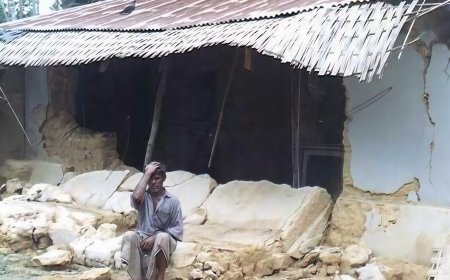
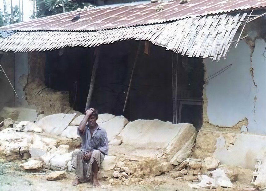
The Narsingdi earthquake registered magnitude 5.5 on the USGS scale and 5.7 according to the Bangladesh Meteorological Department (BMD). The epicenter was located at Madhabdi in Narsingdi, just northeast of Dhaka, with a hypocentral depth of approximately 10km. The main shock was followed by four aftershocks -- the first occurring the next day and the remaining three over the following days.
For many residents of Dhaka Metropolitan City and nearby districts, this was the strongest shaking they had ever experienced. Buildings swayed like pendulums for several seconds, and many people struggled to maintain balance without holding onto walls, furniture, or door frames. Despite the intensity of the shaking, the overall structural damage remained limited, and a widespread collapse of buildings was avoided.
Field investigations revealed ground fractures in several areas near the epicentre. According to geo-scientists from the Geological Survey of Bangladesh, these fractures resulted from soil liquefaction and the subsidence of earth-filled land, rather than from primary fault rupture or surface breaking caused directly by seismic waves. This distinction is important, as it indicates localized ground failure rather than movement along an active fault reaching the surface.
Initial reports indicated that at least 10 people lost their lives, and more than 300 were injured. Numerous buildings developed cracks or showed signs of tilting, especially older or poorly constructed structures.
Ground Fractures
Although Bangladesh is not located directly on a major tectonic plate boundary, the region contains active deep-seated faults. In this case, the Sitalakhya Fault -- not previously identified -- has been suggested as the likely source of the recent earthquake. These faults represent deep fractures in the Earth’s crust, and when stress accumulates over time, sudden adjustments along these fractures can trigger earthquakes.
There has long been academic debate regarding the origin of earthquakes in Bangladesh. Some geo-scientists believe that indigenous earthquakes originate from minor and major deep-seated faults within the country. Others argue that these events may be related to megathrusts or subduction-zone processes affecting the region. Earthquakes generated by fault adjustments are generally not expected to exceed magnitude 7, whereas events associated with megathrust or subduction mechanisms may surpass magnitude 7.
Accurate prediction of earthquakes of any magnitude is not possible without detailed geo-scientific studies supported by high-resolution subsurface data -- research that has never been conducted comprehensively in Bangladesh. Furthermore, the responsibility for providing earthquake-related information to the government and the public has been assigned to the Bangladesh Meteorological Department, rather than to the Geological Survey, which holds the technical expertise in this field.
Earthquake scientists consistently warn that Bangladesh is overdue for a major earthquake. We cannot predict when it will occur -- but we can prepare for it.
Bangladesh has a long and often overlooked history of powerful earthquakes that reshaped rivers, altered landscapes, and transformed human settlements. The absence of recent mega-earthquakes should not mislead us -- the tectonic forces beneath our feet remain active. With millions living in vulnerable buildings, the risks today are far greater than they were in 1762 or 1897.
So, should we care about earthquakes in Bangladesh?
Yes, we must. Our future depends on it.
What's Your Reaction?